15 Dec Long-term traffic monitoring data available
Have you ever wondered how the behaviour of road users changes in snow, fog, rain, darkness, traffic jams, etc.? We know the answer – based on long-term traffic monitoring data.
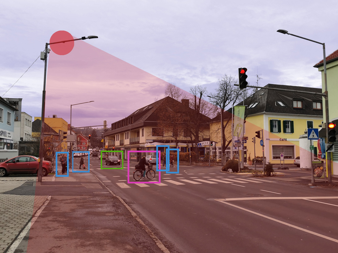
Narrow, foggy streets covered in snow, cyclists overtaking a tram in the middle of an intersection etc. Difficult traffic scenarios like that could pose obstacles for the seamless deployment of autonomous mobility solutions. Compiling a realistic database of different driving scenarios is, therefore, essential for the testing and verification of advanced driver assistance systems (ADAS) and autonomous vehicles (AVs), to ensure that they work well in complex environments.
To build up such a database, ALP.Lab equipped crossings all over Austria with LiDAR sensors. That way, normal traffic can be monitored over months to collect training data fast, cost-effectively and environmental-friendly. The sensors are mounted on street poles or traffic lights, enabling a perfect (GDPR conform) overview over all road users (“bird view”). Using special algorithms, every situation can then be represented from the perspective of each involved car, cyclist etc. (“ego view”) – just like it needs to be to work as training data for autonomous vehicles.

By loading the video, you agree to YouTube's privacy policy.
Learn more
Our already available long-term-data includes:
✔️T-crossing small city (Feldbach): +12 months of data
✔️Complex intersection in larger city (Graz): +10 months of data
✔️City roundabout (Lungau): +8 months of data
✔️One way city street (sensor fusion, Graz): +6weeks of data
✔️etc. (If interested, we can equip the crossing of your choice with sensors.)
Graz 01
By loading the map, you agree to Google's privacy policy.
Learn more
Graz 02
By loading the map, you agree to Google's privacy policy.
Learn more
Graz 03
By loading the map, you agree to Google's privacy policy.
Learn more
Feldbach
By loading the map, you agree to Google's privacy policy.
Learn more
Straden
By loading the map, you agree to Google's privacy policy.
Learn more
Tamsweg
By loading the map, you agree to Google's privacy policy.
Learn more
St. Michael 01
By loading the map, you agree to Google's privacy policy.
Learn more
St. Michael 02
By loading the map, you agree to Google's privacy policy.
Learn more
We provide a live stream (10Hz) of objects passing our covered areas. This data consists of classified road users (e.g. pedestrians, vehicles) including their full trajectory information like position, velocity, heading, object size etc.
Our archived data is available in different formats, like CSV, GPX, OSI, OpenSCENARIO, MDF, MF4. Your benefit: In the postprocessing period we clean the object list data to obtain only valid trajectories and we provide extra information like synchronized weather data, ultra high definition maps etc.
The data is ideal for development, statistical analysis, and research projects. A first sample of data is available on our >> Eco System Plattform.
Get into contact with >> our team, to get further samples and additional information.